 |
| Map of Fort St.George 1862 by Col DM Reid |
 |
Plan de Madras, ou fort Saint-George. 1779. source : http://gallica.bnf.fr
|
 |
| Madras in 1755. Based on "A Plan of Fort St. George and The Bounds of Madraspatnam" by F. L. Conradi. |
 |
| Popham's Broadway (Courtesy: Vintage Vignettes). |
 |
| First Esplanade |
 |
| Second Esplanade |
 |
| Fort Museum I Floor Painting |
 |
| People's Park George Town Madras |
 |
| Stephen Popham |
1778 -- Stephen Popham, a British politician and solicitor, came to India and was employed in Calcutta as Secretary to Sir John Day, the Advocate-General of Bengal. In 1778, Day visited Madras along with Popham. Popham got separated from Day, due to some misunderstanding and heated arguement between them, and stayed in Madras and lived there from 1778 till his death in 1795.
The British settlement in Madras was bifurcated into White Town, comprising the fort and the English buildings within it, and Black Town to the north, the native quarter where also lived the merchants of various races, including Jews and Armenians, who had come to Madras to trade. The city's total population was already around 300,000.
Black Town, which included included Muthialpettah and Peddunaickenpettah, was a mess: although dotted with the villas of merchants and company people who could not get quarters in White Town, it was marshy, squalid, and without proper drainage or streets. A drainage channel running between these two pettahs was known as Attapallam (Aallapallam meaning deep ditch).
1780 -- Since August 1780 Popham started living in Black Town and managed to possess a strip of evil-smelling coastal bog more than a mile long. Stephen Popham's first objective was to improve the amenities of the Black Town and for which he negotiated with the government.
1781 -- The area where the General Hospital, Madras United Club and the Park Town post office stand today, was then a hill called Hoggs Hill by the British and Narimedu (mound of foxes) in Tamil. This natural mound formed as a security threat to Fort St.George. It was Popham who negotiated with the British government in Madras and the mound was levelled after removing excess earth.
1782 -- On January 12, 1782, he submitted "Popham's Plan" to the authorities: "There are no regular Drains to carry off Water, or any well, Sewer, or other provision made to carry off the Ordure, of each House." So he recommended the construction of direct and cross drains in every street. Accordingly the Attapallam and other drains were deepened and a road from north to south along with the Attapallam drainage was laid and this main thoroughfare was known as Pophams Broadway. The Popham's Broadway (present name Prakasam Road) was later called as simply Broadway.
He also submitted a plan for the establishment of a regular police force for Madras. A Board of Police assisted by a Kotwal was subsequently formed. The Kotwal was to be the officer of the markets under the Superintendent of Police.
The Britisher also advocated measures for the naming of streets, provision for street lighting, for the proper registration of births and deaths and for the licensing of liquor, arrack and toddy shops.
The 19th Light Dragoons was a cavalry regiment of the British Army created in 1781 for service in British India. The 19th Light Dragoons regiment arrived at Fort St. George, Madras and became the first British cavalry regiment to serve in India. The 19th Light Dragoons played a major role in the Anglo-Mysore Wars, Anglo-Maratha Wars and the campaign against Tipu Sultan of Mysore.
1783 -- The Fort was very much as it is today. The three-storied structure, housed the Governor's residence in the uppermost floor, with rooms for the Council in the lower ones. A detached gallery of rooms was constructed, enclosing the central building into what was known as the Fort Square.
1785 -- From 1774 until 1858, Madras was a part of British India and was ruled by the British East India Company.
Under the provisions of Pitt's India Act (passed by the Parliament of Great Britain in September 1774 to unify and regulate the administration of the territories of the East India Company), Madras became one of three provinces established by the East India Company. Thereafter, the head of the area was styled "Governor" rather than "President" and became subordinate to the Governor-General in Calcutta, a title that would persist until 1947. Judicial, legislative and executive powers rested with the Governor who was assisted by a Council.
 |
| Fort Museum (Public Exchange House) |
1795 -- Fort Public Exchange established and the Exchange building was built within the Fort by Free Merchants. The construction of the two storeyed Wellesley House was completed in 1795 and the office of the Madras Bank was first housed here. The hall at the first floor functioned as the venue for public meetings and lottery drawing. It also served as the British Infantry Officers’ Mess. It was later converted to Fort Museum in 1948. The museum displays objects dating back to British colonial era including ammunitions, coins, medals, uniforms, portraits of the various Governors of Madras, original letters of Clive and Cornwallis and some artifacts from Britain, France and India. There is also a 14.5 ft tall marble statue of Cornwallis.
The Fort was now self-sufficient. During this phase, the walls too were strengthened. The western front was completely altered. To extend the western side, the course of the Elambore River was diverted by filling the riverbed and the fort turned from square into pentagon shape. A wet ditch or moat was then dug around the main curtain wall and around each of the ravelins and lunettes.
1800 -- Government of England established the Supreme Court of Madras on December 26, 1800.
1825 -- However no further additions were made until 1825, when wings appeared on either side of the western portion of the building overlooking the Parade Square behind.
 |
| Boundary First Esplanade |
1859 -- People's Park (located near the present Nehru stadium) was developed on the southern part of Second Esplanade and the northern part became the Salt Cotaurs.
The people's Park, the brain child of Sir Charles Trevelyan, was opened to public 1859. It measures about 116 acres in size. Part of this park: Madras zoo (1863 - 1985), Victoria Public Hall (1887), Moore Market (1898), South Indian Athletic Association (1902). It had 11 ponds, 5 ½ miles of road and walkways, a bandstand, a public path and two tennis courts.
1861 -- Government of England passed an Act on August 6, 1861, which empowered the Queen of England to erect and establish the High Court of judicature at Madras.
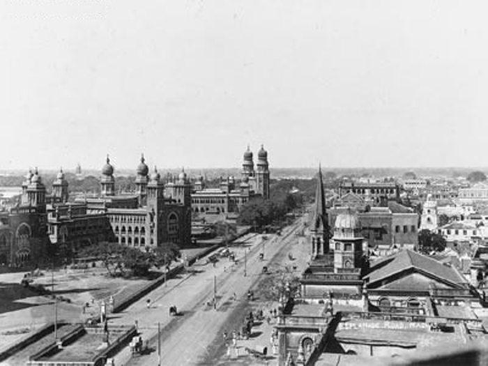 |
| Madras High Court 1905 |
Reference
- A 150-year history The Hindu September 10, 2012
- Broadway, a narrow way S Muthiah The Hindu Chennai March 06, 2000
- History behind the broadway. India Today February 8, 2008 http://indiatoday.intoday.in/story/History+behind+the+broadway/1/4385.html
- Popham the Improver http://www.independent.co.uk/life-style/popham-the-improver-1163210.html
- Stephen Popham (Wikipedia)
- The mystery of a second esplanade The Hindu Chennai, April 14, 2014
No comments:
Post a Comment