Showing posts with label History. Show all posts

Thursday, September 24, 2015

Dandanayakan Fort: Hoysala Commander's Fort forms part of Bhavani Sagar Dam Catchment Area.


Dandanayakan Fort submerged in Bhavani Sagar Dam. PC: Keetru 13 Dec 2012
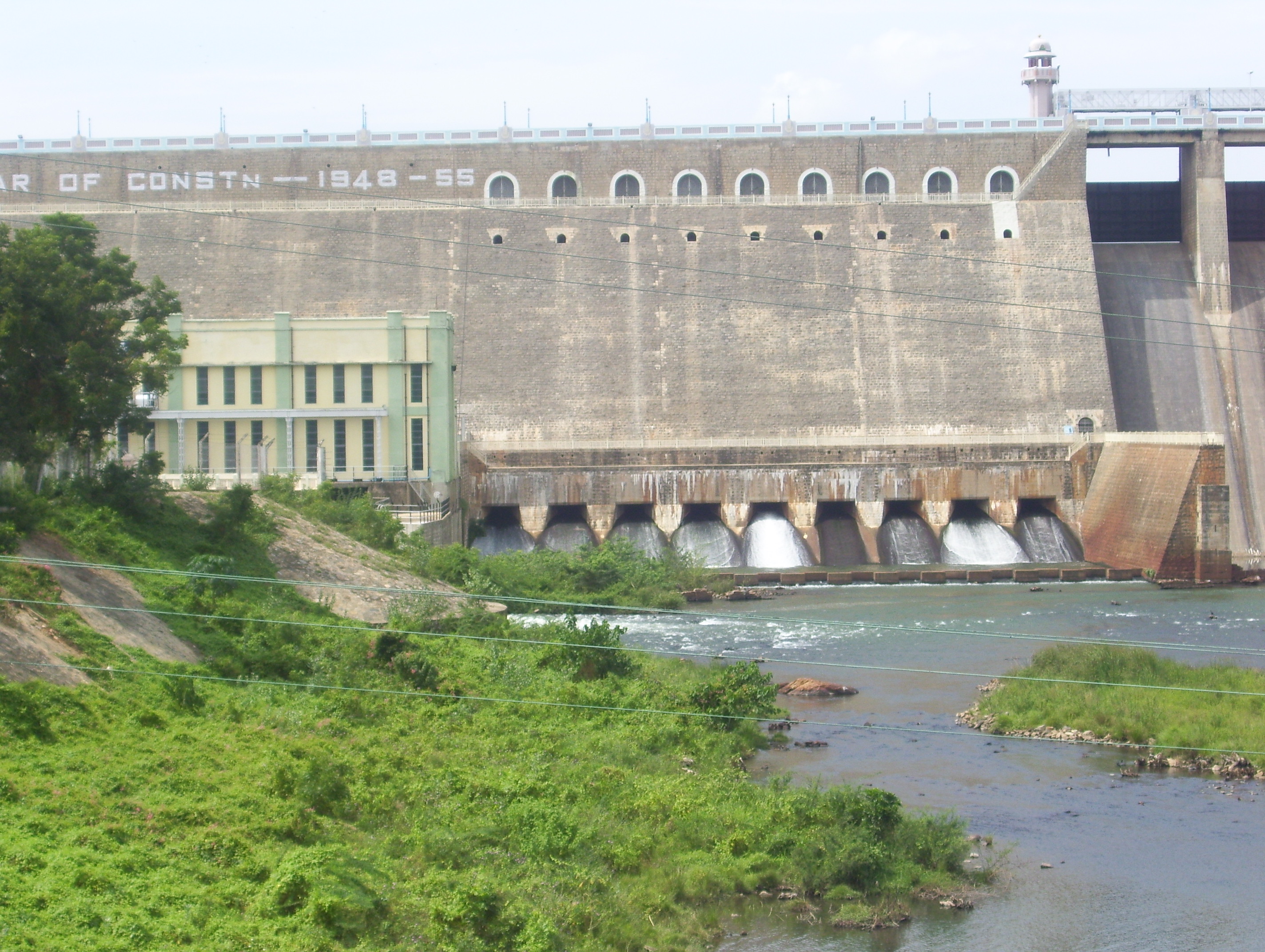
Bhavani Sagar Dam aka Lower Bhavani Dam and Reservoir (Wikipedia)

Bhavani Sagar Dam aka Bhavani Sagar Dam and Reservoir is the prominent earthen dam in India .  The second largest dam in Tamil Nadu  is located  on the Bhavani River in Erode district, Tamil Nadu. The dam with a capacity to store 32.8 tmc of water feeds the Lower Bhavani Project Canal and forms the water source for  the vast swathes of land (2.45 lac acres of land) in Erode & Tiruppur Districts. The irrigation project was the first major irrigation project designed and developed in India after independence in 1947 and came to full function by 1956. It is one the favorite places for picnics and known for childerns' amusement, fun and gaiety.

Whenever the water level in Bhavani agar Dam goes down (total height of the dam -  32 m (105 ft) the visitors can view  the Danayakkan Kottai ‘டனாய்க்கன் கோட்டை’ aka Dhana Nayakan fort. Whenever water level reaches full height the fort gets submerged into the water. According to historians the fort dates back to 1292 and 1341. Before the construction of Bhavanisagar Dam and Reservoir the present catchment area of the dam was occupied by the Dhana Nayakan fort as well as villages like Kooduvoy (கூடுவாய்), Peerkadavu (பீர்க்கடவு) and Kuyyanur (குய்யனூர்). Once it was decided to construct the dam the native people were provided with alternate land for living.  The fort also bears some significant inscriptions.

Kongu Nadu region (Wikipedia)
This region was known as part of Kongu Nadu. Valasundara Kavirayar, probably a seventeenth century poet, hailing from Vijayamangalam (near Perundurai) versifies the borders of the Kongu mandalam as:

வடக்கு நந்திகிரி வராககிரி தெற்கு
குடக்கு பொறுப்பு வெள்ளிக்குன்று
களித்தன்டலை மேவு காவிரிசூழ்
நாடு-குளித்தன்டலை அளவு கொங்கு.  
 - கொங்குமண்டல சதகம்

According to his poem in Kongumandala sathakam (கொங்குமண்டல சதகம்), the Kongu Nadu was bound by Varaka Giri (Panrimalai mountain (பன்றிமலை) in the Palani-Kodaikkanal ranges (பழனி கொடைக்கானல் மலை) in the south, Kudagu (குடகு) and Vellikundru (வெள்ளிக்குன்று) (Kodagu (கொடகு) in the Madikeri dist. of Karnataka and Vellingiri hills (வெள்ளிங்கிரி) near Coimbatore) in the east and Nandigiri (நந்திகிரி) (Nandi hills in Kolar and Tumkur dists. of Karnataka) in the north. The native communities of Kongu Nadu includes Kongar (கொங்கர்), Kosar (கோசர்), Aviyar (அவியர்), Oviyar (ஓவியர்), Veliyar (வெளியர்), Velir (வேளிர்) etc. Agriculture was the major occupation of many of the people in and around this vast region.

The ancient Kongu country was ruled over by the Velir chiefs.  Sources indicate about an active trade between Kongu and the classical Romans during this period. At the end of Sangam Period from about 300 A.D.- 600 A.D., there is a lack of coherent information on the history of Kongu Nadu. The South Western region of Kongu was occupied by Chera rulers; South Eastern part by Pandya kings. Adiyas and Kadavas possessed Northern Kongu.

Imperial Cholas ruled the Kongu region except the south and south-western region which were controlled by the Pandyas and the Chera kings of the Perumal dynasty. During the 10th century A.D., Kongu came under autonomous rule of the members of the collateral Chera family for nearly 300 years and they assumed the titles and names of Imperial Cholas. Thereafter the Pandyas ruled for some time.

Hoysalas, a prominent Southern Indian Kannadiga empire, ruled most of the modern-day state of Karnataka and parts of Tamil Nadu.  The loss of Vira Someshwara (1235–1263) against Jatavarman Sundara Pandiyan resulted in the end of the Hoysala Empire. Jatavarman Sundara Pandiyan went inside Kannada country after conquering Tiruchy and occupied parts of Hoysala territory up to the Konkana coast and established his son Vira Pandiyan as ruler of those territories. The Imperial Cholas made alliance with Hoysalas and this  alliance with the Hoysalas did no good to the Cholas and with the death of Vira Someshwara. The Pandyans got hold of the Kongu territories, Chola Nadu and some of the Hoysala countries during the time and a new clan called Kongu Pandiyar (கொங்கு பாண்டியர்கள்) was established under Jatavarman Vira Pandiyan.

Vira Ballala III (மூன்றாம் வீர வல்லாளா) (1292-1343) was the eleventh and last ruler of Hoysala dynasty. In Karnataka the core area around Mysore right up to Tiruvannamalai (திருவண்ணாமலை) in Tamil Nadu was in the hands of Vira Ballala III. Around c.1310, Ballala III successfully played 'king maker' in the affairs of Tamil country by appointing Sundara Pandya (சுந்தர பாண்டியன்) as the Pandya king as opposed to his competitor, Vira Pandya (வீர பாண்டியன்). In 1327 A.D., Muhammad Tughlaq shifted his capital to Devagiri from Delhi and this has brought enormous Muslim armies dangerously close to the Hoysala capital of Dvarasamudra (துவாரசமுத்திரா). As a precaution, Vira Ballala III had established three capitals: Dvarasamudra (துவாரசமுத்திரா), Kundani  (குந்தாணி) and Tiruvannamalai (திருவண்ணாமலை). He also entrusted the task of defending the Northern frontier of the Hoysala kingdom to the five Sangama brothers (சங்கமா சகோதரர்கள்) of which Harihara and Bukkaraya (ஹரிஹர மற்றும் புக்க ராயா) are the most famous.

Vira Ballala III was engaged in near constant warfare with the genocidal regime of Bahmani and the Madurai Sultanates in desperate attempts to destroy it and liberate the deep south. He was over eighty years old at this time met a tragic end in 1342 AD at the hands of  Ghiyas-ud-din Damghan Shah, a successor of Ahsan Shah. This great defender of Dharma was captured in the decisive battle of Kannur-Koppam  and skinned alive by the blood thirsty Ghiyas-ud-din.

Hoysala Administration

Hoysala Administration was similar to Western Chalukya and Western Ganga Dynasties in relation to political and geographical segregation,  local administration, army and ministry. At the apex, the Hoysala king was supported by the cabinet comprising five ministers (Pancha Pradhanas). This figure grow into higher number at a later date.

Perumal Dandanayaka 

The commanders of the army was known as Dandanayaka (or Senadhipati). Perumal Dandanayaka was the commander of Vira Ballala III and he was responsible in conquering the Kongu Nadu. In order to respect his valor and faith of his Dandanayaka, Vira Ballala gave the part of Kongu Nadu as a gift to Perumal Dandanayaka. The army commander built a fort and ruled this Kongu region. Over a period of Dandanayaka Fort was transformed as Dhannanayaka Fort (தண்ணநாய்க்கன் கோட்டை) and further damaged to Danayakan Fort (டனாய்க்கன் கோட்டை).

Someswara Mangalambika Temple


The Hoysala temple dedicated to Someswara Mangalambika (சோமேஸ்வர மங்களாம்பிகை கோவில்) temple built by Narasimha III (1263–1292) in memory of his father Vira Someswara (1235–1263) is also located nearer to this fort. During Muslim invasion, the forts and Hindu temples were ransacked by the mugal and this fort and temple were also ransacked. Over the years Hoysala came back to power and renovated the fort and the temple. One Ballaya-danadanayakkan (Valiya-dandanayakkan as per inscription) son of  Dutapillai-dandanayakkan of Aranappuram of Madurantakam in Tondaimandalam, undertook the renovation.

Renovation of Someswara Temple by  Ballaya-danadanayakkan

The  undated inscription on the wall of the central shrine, Varadaraja-Perumal temple, Alambakkam, Lalgudi Taluk, Tiruchirapalli District  comprise two sections. The first section is composed in verse as well as in prose and the other section is in prose only. The inscription in verse refers about the renovation of the temples of Dachchina Kailayamudaiyar and Tirumerkoyil (the temple in the west, i. e., Vishnu). The lithic record in prose (below the verse portion) refers about the one Valiya Dandanayakkan (Ballaya-danadanayakkan), son of  Adappillai-dandanayakkan of [Aranappuram] of Madurantakam in Tondaimandalam, who was a dandanayaka  of Narasingadevan (Narasimha III), caused the repairs to this Sri vimana  (of the a central shrine or sanctum) on which the record is inscribed. 

The inscription does not provide the name of the temple. This general or dandanayaka is identical with his namesake who is mentioned as the son of Dutapillai-dandanayakkan in the Tamil portion and as the arbhaka  (son) of Duta in Sanskrit verse in a record (S. I. I., Vol. V, No. 659, verse 1, line 1) from Tirumalavadi in Udaiyarpalayam Taluk of the same district. It is possible that their overlord Narasimha mentioned in these two inscriptions is evidently the same as Hoysala Narasimha III (1263–1292), who held sway over this area. It may be said from the above records that his reign period witnessed many benevolent acts including the construction of a tank called Madurantakappereri. One the grounds of paleography Narasimha may be considered to be identical with the second king of that name. The temple may be considered as Someswara Mangalambika (சோமேஸ்வர மங்களாம்பிகை கோவில்) temple built by Narasimha III (1263–1292). 

Reference:

  1. South Indian Inscriptions. Volume 26 Introduction_2
  2. Vijayangar Chapter 6: The Great war of Liberation
  3. அணைக்குள் மூழ்கிக் கிடக்கும் கோட்டை தினகரன்
  4. பவானிசாகர் அணைக்குள் மூழ்கிக் கிடக்கும் பழம்பெரும் கோட்டை தினமலர் 01 ஆகஸ்ட் 2010
  5. பவானிசாகர் அணையில் நீர் மட்டம் குறைந்ததால் வெளியே தெரியும் கோட்டை கோவில் மாலைமலர் மே 27 2012
  6. பவானிசாகர் நீர்மட்டம் சரிவு கோயில்கள் வெளியில் தெரிகின்றன தமிழ் முரசு 08 March  2013
  7. சத்தியமங்கலம் வனம் - தமிழகத்தின் பசுமை நுரையீரல் கீற்று  13 டிசம்பர் 2012

Wednesday, September 16, 2015

Penneswaramadam Temple Inscription: How the Vira Ramanatha, Hoysala Ruler kept corruption at bay?


Sri Vedanayagi sameda Penneswara Nayanar temple
  • பென்னேஸ்வர மடம் கோயிலில் உள்ள கல்வெட்டை காட்டுகிறார் வரலாற்று ஆய்வாளர் சுகவன முருகன்.
    Sugavana Murugan, Freelance Archaeologist shows the Hoysala King Vira Ramanatha's inscription in Penneswaramadam Temple, Krishnagiri District, Tamil Nadu.
  • தலை துண்டிக்கப்பட்டவரின் உருவம் கொண்ட கல்வெட்டு.
    நவகண்டம் கல்வெட்டு.
The temples, during 13th century Hoysala rule, were degraded themselves to grossly corrupt practices. Vira Ramanatha (1253 to 1295 A.D.), the tenth Hoysala ruler showed  zero tolerance towards corruption. The Tamil Grantha inscription inscribed by the king in Penneswara Nayanar, Penneswaramadam clearly indicate how intolerant against corrupt practices and the violators of ethical framework. The Hoysala king has adopted anti-corruption measures in favor of his people.

Shri. Sugavana Murugan (pudhuezuthu), the scholar,  a government school teacher and also a freelance archaeologist, District Archaeology Centre of Kaveripattinam, Krishnagiri district has informed about the recording of the Tamil Grantha inscription by Shri. Su. Rajagopal and Shri. Su. Krishnamoorthy of the State Department of Archaeology.

The translation of the inscription in the Tamil Grantha script has been recorded by Su. Rajagopal and Su. Krishnamoorthy of the State Department of Archaeology, says Sugavana Murugan of the District Archaeology Centre. 
Penneswaramadam,  a panchayat village located on the bank of the South Pennar River  in Krishnagiri taluk Krishnagiri district PIN 635112. The village is approximately 100 kilometres  from Bangalore and.5 km from Kaveripattinam and 34 km from Dharmapuri. Penneswaramadam is geographically located at latitude 12 ° 23′0'' and longitude 12 ° 23′0''. Near by railway Stations are Bangarapet.

The 12th century Chola temple dedicated to Penneswara Nayanar (Lord Shiva) and his consort Sri Vedanayagi Amman.   The Penneswara Nayanar Shrine consists of a vimana, ardhamandapa and mukhamandapa. The vimana is a single tier structure with an adhishthana, pada, prastara, shikara, griva and stupi. The roofs of ardhamandapa and mukha mandapa are supported by vratta sthambas. The sanctum of the prime deity is facing east. The seven tier rajagopuram faces the south.

The vimana is surrounded by the cloister mandapa (thiruchurru malikai) with a row of pillars in the periphery. Subsidiary shrines for Vinayaka, Saptamatrikas, Surya and Chandra. The sanctum at the north-west corner of the temple houses the goddess Sri.Vedanayaki Amman. To the west there is a shrine for Rama, Lakshmana, Sita and Hanuman.

The Penneswara Nayanar temple also owns Navagandam panels. The specialty of the temple is that there is a practice of navagandam. Navagandam is the practice of individuals slicing their neck with a sword to the goddess. The supreme sacrifice often committed Kottravai, the war deity, involves in chopping off nine parts of one’s own body progressively. The individual offers his life for the welfare of the ruler and success in battles he leads.

Krishnagiri Region 

The present Krishnagiri and Dharmapuri district was known as 'Adhiayaman Nadu'. It was ruled by  Pallavas, Gangas, Nulambas, Cholas, Hoysalas, Vijaya Nagar Emperors, Bijapur Sultans, Wudayars of Mysore and Nayaks of Madurai. The regions including  'Krishnagiri', 'Hosur' and 'Uthangarai' were forming part of 'Eyil Nadu', 'Murasu Nadu' and 'Kowoor Nadu' respectively. Under Chola rule, Krishnagiri region was known as 'Nigarili Chola Mandlam' and 'Vidhugadhazhagi Nallur'. During 'Nulamba' rule it was called as 'Nulambadi.'  The 'Bara Mahal' Forts and the Krishnagiri region served as the west gateway of Tamil Nadu and defended the invasions. The Hoysala king Vira Ramanatha made "Kundani" a place in Krishnagiri District as his Head Quarters in 13th Century A.D. 

Inscriptions     

Over forty inscriptions have been discovered from this temple complex. They belonged to the reign of Hoysala, Chola and Vijayanagara kings. They have gifted gold, tax free land and other gifts to Penneswara Nayanar of Penneswaram. The inscription of Vira Narasimha, the Hoysala King records the land donation to the Pannai Nayanar by one Madurantaka Viranulamban Vairavan Vimalan. The land records also mention about lands located in Peruman Koyil Kollai, Thattankuttai, Mahadevan Kollai, Sirukkan Kollai, Puliyamadai etc.

An inscription of Vira Ramanatha Devarisa found in Tamil Grantha script - Tamil language on the wall of the Penneswara Nayanar temple in , Penneswaramadam is of great significance. It records the royal order issued by the Hoysala ruler Vira Ramanatha, dated regnal year 46.

"ஸ்ரீ வீரராமந்நாத தேவரீஸர்க்கு யாண்டு நாற்பத்தொன்றாவது உடையார் பெண்ணையாண்டார் மடத்தி லும் பெண்ணை நாயனார் தேவதானமான ஊர்களிலும் ஒரு அதிகாரியாதல் கணக்கர் காரியஞ் செய்வார்களாதல் கூசராதல் ஆரேனுமொருவர் வந்து விட்டது விடாமல் சோறு வேண்டுதல் மற்றேதேனும் நலிவுகள் செய்குதல் செய்தாருண்டாகில் தாங்களே அவர்களைத் தலையைஅறுத்துவிடவும் அப்படி செய்திலர் களாதல் தங்கள் தலைகளோடே போமென்னும்படிறெயப்புத்த பண்ணி இதுவே சாதனமாகக் கொண்டு ஆங்கு வந்து நலிந்தவர் களைத் தாங்களே ஆஞ்ஞை பண்ணிக் கொள்ளவும் சீ காரியமாகத்தாங்க . . . த. . . போதும் போன அமுதுபடிக் குடலாக ஸர்வ மானிய மாகக் குடுத்தோம். அனைத் தாயமு விட்டுக்கு . . .கூசர் உள்ளிட்டார் பையூரிலே இருக்கவும் சொன்னோம். இப்படியாதே இதுக்கு விலங்கனம் பன்னினவன் கெங்கைக் கரையில் குராற் பசுவைக் கொன்றான் பாவத்தைக் கொள்வான்" 

Meaning: "The record is dated in the 49th year of king Sri Viraramanatha Devarisar. Anybody seeking cooked food or indulging in other corrupt practices in Pennaiyaandaar madam (பெண்ணையாண்டார் மடம்) and its endowed land (Pennai Nayanar devadanamana oorgalilum - பெண்ணை நாயனார் தேவதானமான ஊர்களிலும்) shall be beheaded, and any official like Kannakkar, Adhigaarigal (அதிகாரியாதல் கணக்கர் காரியஞ் செய்வார்களாதல்) refusing to act on this order will face a similar fate.”   Registers an endowment of  land (ஸர்வ மானிய மாகக் குடுத்தோம்) for feeding the poor mendicants (நலிந்தவர்கள்). The order was strictly enforced. Whenever one violates the natural moral order established by the king, one sins and incur the sin of killing cow (குராற் பசு) on the bank of river Ganges.

Savulur Panchayat Union Middle School students have discovered a pre-historic site near Penneswara Nayanar  temple during April 2015. They have also collected artefacts dating back to 2000 years from the site near the temple.

In the Vijayanagar period, Madras Port became a well known port. This is evident from a Vijayanagar inscription found in Penneswaramadam, on the banks of the Pennar, to the South of Kaveripattinam. The inscription is dated July 21, 1367. It is about the digging of a canal in the time of Kampanna II. “This king’s conquests and victories in Tamil territory are also recorded in this inscription, and the names of ports, forts and villages on the East Coast, which he captured from Tondaiman, give us clues about Maadarasanpattanam,” says Rajavelu.

History of Hoysalas
  • Place        Karnataka
  • Period        10th to 14th Century
  • Language    Kannada
  • Religion    Hindu
  • Hoysala Kings: 1. Nripa Kama II (1000 to 1045 A.D.), 2. Hoysala Vinayaditya (1045 to 1098 A.D.), 3. Ereyanga (1098 to 1100 A.D.), 4. Veera Ballala I (1100 to 1108 A.D.), 5. Vishnuvardhana (1108 to 1142), 6. Narasimha I (1142 to 1173 A.D.), 7. Veera Ballala II (1173 to 1220 A.D.), 8. Vira Narasimha II (1220 to 1235 A.D.), 9. Vira Someshwara (1235 to 1253 A.D.),  10. Narasimha III and Vira Ramanatha (1253 to 1295) and 11.Veera Ballala III (1295 to 1342. A.D.).
The 346 year rule of the  Hoysala dynasty (1000 A.D. to 1346 A.D.) is looked at as the second most flourishing and mighty period in the Karnataka history next to the powerful Vijayanagara Empire. This South Indian Kannadiga empire ruled most of modern day state of Karnataka and Belur was their capital during initial 150 years and later moved to Halebid due to hostility and repeated invasions. Taking advantage of the warfare between the then Western Chalukyas and Kalachuri kingdoms, they also conquered the present day Karnataka and the fertile areas north of the Kaveri River delta of the present day Tamil Nadu. By 13th century, they governed most part of the of the present-day Karnataka, minor parts of Tamil Nadu and parts of western Andhra Pradesh in Deccan India. Narasimha II, the seventh Hoysala ruler conquered Tiruvannamalai in Tamil Naduto make it his winter capital. 
 
Vira Somesvara (1235 to 1253 A.D.), before his death bifurcated his kingdom between his two sons, Veera Narasimha and Vira Ramanatha. His sons, however, later fought a civil war. Vira Ramanatha confederated himself with Rajendra Chola Deva III. Both were later to be overpowered by Maravarman Kulasekara Pandiya, who impounded their territorial dominion. Vira Narasimha's successor was Ballala III aka Veera Vallalan, Emperor of the South (1291 - 1342 AD). Although still hostile, Ballala's succession was not disputed by Vira Ramanatha, thus Ballala was able to rule over a united Hoysala Kingdom until approximately by  1300 A.D.
Vira Ramanatha's accession to the Tamil districts took place about 1255 A.D. and his inscriptions of the 12th, 15th and in the 17th years, which correspond to 1267, 1270 and 1271 A.D. are found at Srirangam and Kannanur. The king attended to the checking of the revenue accounts in the 4th year of his reign; the communal repairs made to the Vanigan's well now known as Nalummulaikkeni at Tiruvellarai, whose walls it is stated, had sunk in on the four sides probably on account of heavy rains in the 8th year of the king, and exempted the tax on salt dealers at Tirumalavadi. He made to the temple of Sri Ranganatha at Srirangam, a gift of a gold crown set with jewels, two fly whisks with the handle of gold and a kalanji (betel pot). He was succeeded by his son Vira Viswanatha in 1293 - 94 A.D; after which the kingdom merged into then rising power of Vijayanagara Empire.  

These rulers were initially inspired by Jainism but from the Vishnuvardhana’s period onwards they were all Vaishnava Hindus and were great patrons of the temple architecture of Belur, Halebid and Somanathpura. The Hoysala dynasty is well remembered for the the hallmark of their temple architecture as well as for the exquisite workmanship on a massive scale in Belur, Halebid, Somanathapur, Arasikere and Amritapura in the Karnataka State and Tiruvannamalai in Tamil Nadu.

Reference:

  1. History of Krishnagiri District  http://www.krishnagiri.tn.nic.in/history.htm
  2. Hoyala Dynasty. Indian Mirror.com  http://www.indianmirror.com/dynasty/hoysaladynasty.html
  3. Madras is not alien by Suganthy Krishnamachary. The Hindu August 21, 2014
  4. Perils of corruption: a note from Hoysala ruler by PV Srividya. The Hindu  October 11, 2014
  5. லஞ்சம் வாங்கினாலும், கொடுத்தாலும் மரண தண்டனை விதித்த மன்னன்: 700 ஆண்டுகளுக்கு முந்தைய கல்வெட்டில் தகவல். எஸ்.கே.ரமேஷ். தி இந்து அக்டோபர்  10, 2014

Sunday, June 28, 2015

Permanent Cinema Theatre in India was first built in Madras 1911: History

1897: In 1897, M. Edwards first screened a selection of silent short films at the Victoria Public Hall in Madras. The films all featured non-fictional subjects; they were mostly photographed records of day-to-day events.

1909: Swamikannu Vincent, a railway draftsman from Tiruchirapalli, became a travelling exhibitor in 1905.  near the present Parry's Corner, using carbide jet-burners for projection
It was Swamikannu Vincent who made humble beginning with his 'Tent Kottai' helped to introduce theatre culture in Tiruchi as well as in South India. Vincent must also be credited for setting up Edison's Bioscope in Esplanade (near the present Parry's Corner), and laid the foundation of the movie business in the South as a supplier of film projectors. He bought the film projector and silent films from the Frenchman Du Pont and screened silent films using carbide jet-burners for projection and set up a business as film exhibitor.
The Broadway Bioscope, 16 Popham's Broadway, George Town, (The Hindu)
The Broadway Bioscope Interiors (The Hindu)
1911: It is well established now that a woman by the name of Mrs. Klug, was the first to establish a ‘permanent' cinema theatre on the first floor of No. 16, Popham's Broadway in George Town (just south of Loane Square and opposite Harrison and Co.) in  April 1911 in Madras. However it was  not a purpose-built theatre for film shows, but was an already existing space modified and redecorated for use as a theatre. This was known as “The Broadway Bioscope” or simply “The Bioscope.”  Mrs Klugg’s Bioscope in Broadway, lasted only for just six months.
Major Warwick Electric theatre screened movies in 1913

1913: For many years it was widely reported that the first permanent cinema theatre in India was the 'Major Warwick Electric theatre' started in Madras by Major Warwick during 1900.  However the theatre began screening films only in 1913. It was a purpose-built cinema theatre in Madras and had a highly successful run over 21 months. The very same building survives still today as the Philatelic Bureau of the Mount Road Post Office.
 

1913:  In 1913 the Lyric theatre (calling itself as Empire Cinema) began screening films at the first floor of the building named Misquith & Co (A hall known for entertainment at the junction of Ellis Road and Wallajah Road. (Wallace) since 1842).  A fire accident in March 1914 made them to close it down. Later that year, J F Madan of Calcutta, owner of India’s biggest cinema chain at the time, took over the Empire and renamed it with that of his flagship, the Elphinstone. The Elphinstone theatre with balcony for the first time commenced screening films from 1916.

Raghupati Venkaiah Naidu
First Permanent Theatre Built by an Indian (Raghupati Venkiah Naidu)
1914: In 1910, Raghupati Venkaiah Naidu of Machilipatnam, Andhra Pradesh, known widely as the father of Telugu cinema and  a pioneer in the production of silent Indian films and talkies, established Tent Cinema House at Esplanade i.e, near the Madras High Court to exhibit his films. He also screened the short films in the Victoria Public Hall.
In 1912, he constructed Gaiety Talkies on Mount Road, the first Indian-owned cinema theatre in Chennai. Gaiety Talkies commenced screening films in 1914. He later constructed Crown Theatre on Mint Street and Globe Theatre in Purasawakkam (later called Roxy), Chennai. He also exhibited American and British films.

The Elphinstone re-opened in 1916, Wellington in 1917, Paragon 1934, Globe (near LIC building) in 1938, Casino in 1941, Chitra in 1948

Shanthi Theatre, First Airconditioned Theatre of Chennai, was inaugurated on 12.01.1961 by Shri K. Kamaraj, then Chief Minister of Madras State.

Sapphire, Blue Diamond and Emerald - the first of its kind multiplex in India — drew a large crowd.

Saturday, May 31, 2014

How Loane's Square park in Broadway Chennai got its name?

Section of the Park named after Potti Sri Ramulu, Mayor Chennai Corporation
Loane's Square Park shown in Green Rectangle
Have you ever wondered how the park at the junction between Broadway and Audiappa Naicken Street got its name as 'Loane's Square Park?' There an interesting story behind this park and in naming too.
Popham's Broadway  (named after British politician and solicitor Stephen Popham who was determined to improve the sanitation in the late 18th century), later simply known as Broadway, is the historical thoroughfare of the George Town developed by Colonial Madras Local Administrators. The arterial road running along north to south divides George Town exactly two divisions i.e,  Peddanaickenpet and Muthialpet. Only fewer people will able recognize Popham's Broadway.

During early 18th century there was a growing population and commercial activities in George Town. The need for a market with separate points for vegetables, meat and fish was demanded by public. The Colonial administration chose a vacant site at the junction between  the Broadway and (present) Audiappa Naicken Street in George Town and the land was owned by  Stephen Popham. The market place was constructed and thrown open to public in 1780s. The market place was also named as 'Popham's Market.' The market at Broadway survived for over a century. The market also showed signs of wear and tear and the authorities condemned the site as unsanitary.

There was congestion in Black Town, resulting in dispersion of some of the population to neighbouring areas. The site within people's park near Central Railway station was earmarked for the new market. Soon Col. Sir George Montgomerie John Moore, then President of the Madras Corporation laid the foundation stone for Moore Market in 1898. Designed by RE Ellis in the Indo-Saracenic style in a series of quadrangles enclosing shops, it was constructed by A Subramania Iyer. The market, opened in 1900, was considered as the modern with facilities for vegetables, flowers and meat and the same venue was known for  curios including antiques, art, books and pets.

Popham's market was demolished and the site was converted into a park. The Park was named as 'Loane's Square Park' after Samuel Joshua Loane's, Engineer of the Madras Corporation who was responsible for constructing Moore Market.  Now Loane's Square Park is rechristened  as Sriramulu Naidu Park, named after Potti Sri Ramulu Naidu, former Mayor of Chennai Corporation.

Popham’s was demolished, making way for a park – Loane’s Park, named after Samuel Joshua Loane, Engineer of the Madras Corporation who was responsible for constructing Moore Market. It is now known as Sriramulu Naidu Park, after a former Mayor of the city.

Reference

  1. Before the malls, there were the markets XS Real.com February 9, 2012
  2. George Town, Chennai, Wikipedia
  3. Moore, of Moore Market by V Sriram. Madras Heritage and Carnatic Music. August 17, 2012
  4. Stephen Popham, Wikipedia

Wednesday, May 7, 2014

Curzon and Company: Colonial Furniture Shop at Mount Road, Madras

Curzon & Co Colonial Furniture Shop @ Mount Road - Ellis Road Intersection
Mr. Chimato Seshachalam the son of Alavandar
George Nathaniel Curzon, 1st Marquess Curzon of Kedleston, KG, GCSI, GCIE, PC (6 Jan 1899 – 18 Nov 1905)

Curzon & Co, the  116 year old furniture dealers and carpenters, is housed in a characteristic  two-story colonial style building at  No 137, Opposite MLA Hostel Near Anna Statue, Wallajah Road, Mount Road, Chennai - 600002. The shop was inaugurated in 1898 by Chimato Alavandar Chetty when Lord George Nathaniel Curzon, the 1st Marquess Curzon of Kedleston, the Viceroy of India visited Madras. This event could have prompted Alavandar Chetty to name the shop in honour of Lord George Nathaniel Curzon. To keep pace with time the family partnership business is managed at present by the members of the fourth generation.  
George Nathaniel Curzon, 1st Marquess Curzon of Kedleston, KG, GCSI, GCIE, PC (11 January 1859 – 20 March 1925),

One can easily findout this oldest surviving furniture shop and the unique signboard, 'Curzon' at the interection of Wallajah Road and Ellis Road. This  imposing colonial style building, with grand front entrances, tall columns, high ceilings, arches, houses the antique rosewood rolltop desks, colonial sofas, huge size rosewood cots and many more teak furniture items.

Mr. Chimato Seshachalam the son of Alavandar was only six years when his father expired. With the support of his maternal family he graduated law and even served in the chambers of V. Krishnaswami Ayyar. Since the family persuaded his presence in the family business, he associated himself in this business. His initiative in specialising in library furniture with the guidance of Dr S. R. Ranganathan, the father of Indian library science, brought name and fame. The Curzon's library furnitures are still in use at Madras University Library, Dr. Ambedkar Law University, Madras Medical College, Bishop Heber College (Trichy), Madras Institute of Development Studies, and Pachaiyappa's College. The furniture are also in use at Raj Bhavan, Chennai, government offices in Kurnool and at few residences of people like M.S. Subbalakshmi.

Mr.C.Seshachalam,  popularly known as ‘Curzon Chettiar', established the first saw mill in 1935 in Guindy and brought innovation in his carpentary workshop through mechanized planing, cutting of wood and furniture assembling. Curzons was able to withstand the competition with Spencers and Wrenn Bennett.

Now the legendary furniture showroom has reached its centenary year in 1998 and today most of what remains is Curzon & Co's rich history. 

Reference:   

  1. Once, viceregal furniture by S.Muthiah. Chennai. The Hindu Jun 13, 2005
  2. Survivors of time: Of time and tables Asha Sridhar Anusha Parthasarathy The Hindu  August 23, 2011

Wednesday, April 23, 2014

Evolution of Fort St.George 1939 (As Documented by Col.DM Reid) and Present Structure


Fort St.George Map 1939 Col.DM Reid
Post & Telegraphs: Special Cover 368th Madras Day Celebrations 22-08-2007
Wallajah Gate (Island Grounds) Fort St. George
Gate Used by Military Units at Fort St.George
North Gate Fort St. George
Bastions and Revelins of Fort St.George
At the Fort Museum, one can see maps and illustrations which documents the evolution of the fort and settlement over the centuries. Col. D.M.Reid (Douglas Muir Reid) prepared drawings of the fort with Madras volunteers. These drawings describe the evolution of this fort. He has also written a book title: 'The Story of Fort St. George.'

1687 -- Governor Elihu Yale erected the 45-m (148-ft) tall flagstaff to hoist the Union Jack for first time in India.  

1715 -- The Parade ground behind the Secretariat building was known as  Cornwallis Square.

1726 -- Marmalong Bridge, the first across the Adyar River. Built by the Armenian Coderjee Petrus Uscan.

1755 -- The Wallajah Bridge was constructed connecting the Wallajah Gate of the Fort to the Island. 

1825 -- Binny Bridge, named after John Binny, whose residence became the Imperial Hotel - now the Vivanta by Taj Connemara, also known as Commander-in-Chief’s Bridge, was constructed in Binny Road.

1829 -- Anderson Bridge, named after Dr. James Anderson, who had a botanic garden in the area once, was constructed across coovum and lies adjacent to Pantheon road signal. 

1840 -- Elphinstone Bridge constructed on River Adyar

1869 -- Napier Bridge,  which connects the entire stretch of the Marina with the Fort, was  constructed by Francis Napier, then Governor.  The Napier Bridge we know today, with its six bowstrings and ethereal lighting at night, was built in 1999.  

1910 -- A second floor over the wings and the magnificent Assembly Hall to the east with numerous black columns were added enhancing its facade.

1930 -- The low width North and South Sea Gates, which remain closed for a longer time, were estimated as too small and hence they were replaced with much wider structures.

1942 -- The small Centre Gate was not used for a longer duration and it was sealed with bricks. The closure also to protect the fort from threats posed by the Japanese.

When completed, Fort St. George was spread over 42 acres inside and over 60 acres outside the Fort Walls. The Fort had 3 principal gates, the “Sea Gate”, which has now been closed, the“Wallaja Gate” and “St. George Gate” apart from a few minor gates. The Gates were further strengthened by bastions, ravelins flanked by lunettes. A wet ditch was built all around the Fort as an added security measure.

Tamil Nadu State Government's Neo Classical Secretariat is visible to those who enter through Sea Gate


Fort St.George Borders:
  • Western side border: the Wall Tax Road and the Buckingham Canal
  • South side border: the North Fort Road on the eastern side and the General Hospital Road on the western side
  • Northern side border:  Basin Bridge Road and Old Jail Road
  • Eastern side border: the Rajaji Salai (First line beach road) and the Chennai Port
  • All the four sides are additionally bordered by railway lines of the Chennai Beach—Chengalpattu and Chennai Central—Chennai Beach sections.

The streets (some of streets and monuments are seen even till date) were named in the 17th Century when the Fort was a residential settlement, `White Town'. All the main streets were parallel to the coast and developed around the core, `The Castle' (The Fort).

Streets  within Fort St.George:

Sl.No. Name of the Street Thumbnail of the Street
1 Church Street
Location: Right side of the Fort House
2 North East Parade Street Location: Parade Grounds

3 Kings Barracks Location: CSD Canteen
4 Glouceter Street  Location: Fort Square
5 York Street
Location: Fort Square
6 Middle Street        Location: Fort Square
7 Charles and James Street
  Location: Clive House

8 St. Thomas Street
Location: Near Church Street
9
Oultry Street
Location: Near Parade Ground
10 Choultry Street

Location: Parade Ground
11 Inner street
Location: South West

12 Wallajah West Street  Location: South West
13 Saint George Curtain StreetLocation: St. Thomas Street
14 Inner George Gate Street
Location: West
15 Inner North Gate Road   Location: York Street

Monuments within Fort St.George, Esplanade and George (Black) Town:

Sl.No. Name of the Monument Thumbnail of the Monument
1 “Tamil Nadu State Government Secretariat (British East India Company Fort House)” . Location: Central Building
2 “Elihu Yale’s home” . Location: St.Thomas Street
3 St. Mary’s Church with tablets laid on the ground and enclosed by a compound and a buried wall  Location: Church Street
4 Clive’s house built in 1753  Location: Charles and James Street
5 “Arsenal” between Wellesley house and Clive’s House with shells and cannons piled together near the Gateway Block IV/1-12 and 14-18. (Wikimedia Commons)
It was designed by Colonel Patrick Ross and is presently being used by the military as their supply depot. 
Location: Charles and James Street
6 Wellesley house (Built in 1798), Block No. IV/13         Location: Charles and James Street
7 Big Warehouse, south of the Church Library (in Block No. II/7).
It is situated right opposite the Last House on Snob’s Alley and is in a complete state of disrepair with half of the roof structure having caved in. (Wikimedia Commons)
Location: St. Thomas Street
8 Chaplain’s house including portion which is the northern side of the old Wall II/1. (Wikimedia Commons)

Location: St. Thomas Street
9 Garrison Engineer’s Depot, Block No. IV

It is located opposite the Fort police station which is now in military use. 
Location: Charles and James Street
10 Guard room Block No. V Fort St. George, Chennai-9
11 King’s Barracks Block No. XXV  Location: Kings Barracks now Area CSD (Defence) canteen
12 Last house on the left of ‘Snobs Allay’ (Oldest house in the Fort with carved staircase) – Block No. I/1

It is now completely ruined with little trace left of its presence and is presently being restored by the ASI. (Courtesy: The sorry state of Fort St George Madras Heritage and Carnatic Music March 5, 2014 )
Location: St. Thomas Street
13 Nursing Sister’s House (Block No. I/3)

Located in a building to the north of the Last house and is in good condition. It is currently being used as residence by some of the church staff and nuns from St. Mary’s Church.

Location: St. Thomas Street
14 Old British Infantry Officer’s Mess (now housing the Fort Museum) Block XXXVI/2   Location: York Street
15 Ramparts, gates, bastions, Ravelins with vaulted chambers and water cisterns underneath; moat and defence walls all round with glacis to the extent of the existing barbed wire fence
16 Tomb of David Yale and Joseph Hymners in the compound of Law College, George Town

The proposed alignment and Chennai Metro Rail Station comes within 300 meters of the Tomb of David Yale and Joseph Hymners located inside Dr. Ambedkar Law College campus.
17 Old town Wall Tondiarpet, Chennai

Reference
  1.  Bridges of Madras - The concrete connect. Anusha Parthasarathy The Hindu Chennai April 16, 2013
  2. Exploring the Fort St. George: A neglected heritage complex by Anand Lakshmipathi Transparent Chennai April 1, 2013 
  3. List of Centrally Protected Monuments - State-wise, Tamil Nadu, Archaeological Survey of India Chennai Circle
  4. The sorry state of Fort St George Madras Heritage and Carnatic Music March 5, 2014 

Saturday, April 19, 2014

Evolution of Fort St.George 1758 (As Documented by Col.DM Reid)

Map of Fort St.George in 1758 by Col DM Reid
John Lodge Map 1747


Siege of Fort St.George December 1758 and February 1759
 
Siege of Pondicherry 1760
At the Fort Museum, one can see maps and illustrations which documents the evolution of the fort and settlement over the centuries. Col. D.M.Reid (Douglas Muir Reid) prepared drawings of the fort with Madras volunteers. These drawings describe the evolution of this fort. He has also written a book title: 'The Story of Fort St. George.'

1746 -- Battle of the Adyar River took place at Quibble Island, near the Adyar River on 29 October.
Quibble Island - Battle of Adyar River


1746 between the 300 men of the French East India Company led by Captain Paradis and a much larger force of 10,000 men belonging to Anwaruddin Muhammed Khan, the Nawab of the Carnatic. The Nawab claimed Madras from the French and  the French won and occupied Santhome. The Battle of the Adyar River acclaimed the advent of modern artillery warfare into the country's antiquated military system (cavalry). The battle led to their formation of the regiments that were to prove the nucleus of the Indian Army.

1746 - 1763 -- Three Carnatic Wars were a series of battles, primarily between the East India Companies of the British and French, for control of the trading ports of India.

1746–1748 -- The first Carnatic War was the fallout of the Austrian war of succession, in which France and England were in opposite camps.

Mohammed Ali, Nawab of Arcot
1749–1754 -- The Second Carnatic War was closely linked with the dispute of succession in the Nizam Hyderabad and over the Nawabship of Carnatic. The French supported Chanda Sahib, who claimed the throne of Carnatic and the British supported Mohammed Ali. The troops of Robert Clive with the support of Marathas defeated Chanda Sahib.  Clive captures Arcot and the English emerge victorious. Mohammed Ali the Nawab of Arcot, became the undisputed leader. The Nawab of Arcot gifted Santhome to the English.
Kings Barracks Fort St.George

1755 - the King’s Barracks were built at Fort St.George to accommodate the bachelor officers and ranks of the East India Company Army. This King's Barracks was spreading over 10,000 sq.meters. A Grand Arsenal was added to store the ammunition required for the Carnatic Wars and some private property was acquired to build barracks for the soldiers.
1756 - To expand the Fort St.George, the small Elambore River flowing as the Western defence was diverted by filling Earth. The massive quantity of Earth was obtained by leveling the natural mound called “Hog’s Hill” (Narimedu) located further West. Cisterns were built to support water requirements for about 6000 men.

1757–1763 -- The Third Carnatic War was merely an echo of the Seven Years' War in Europe. The French Government sent a powerful army under the command of Thomas Arthur Comte de Lally to mitigate the influence of the British in India.

1752 -- Madras once again became of the seat of the Presidency.
1756 -- Period of hectic construction and reconstruction of the Fort, most of which remain today. Strengthening of the western front of the Fort and leveling of Hog Hill, the natural mound further west. King's Barracks built within the Fort to house the King's Regiment.

When war broke out with Great Britain, the French government chose Thomas Arthur Comte de Lally to command a French expedition to India.

1757-58 -- Demolition of the old Town Temple. Building of the northern face of the Fort St.George

1757 -- This expedition took a certain time to organize and finally it left Brest in May 1757.
1758 -- French expedition to India with Lally and staff reached Pondicherry on April 7 1758.
In May 1758, his troops captured Cuddalore.  

In December 1758 Lally laid siege to Fort St.George (siege of Madras). The Siege of Fort St.George commenced in December 1758 and continued for 67 days by French forces under the command of Lally during the Seven Years' War. The siege was lifted with the support of British fleet in February 1759. Comte Lally anchored his artillery at a remote place (present Parrys corner) and his French artillery managed to maintain uninterrupted shell fire for 46 days. As a result the fort was reduced to crash including the storeyed houses within the Fort. The British troops also retaliated 26,554 cannon balls and more than 200,000 cartridge rounds in defence of the town.

1759 -- Despite bombardment of Fort St. George over nine weeks, Lally and the French troops were  forced to raise the siege of Madras on February 16 - 17, 1759. The failure to capture Madras was a huge disappointment for the French and a massive setback to their campaign in India compounded by the later Battle of Wandiwash.

1760 -- On January 22 1760, Lally was defeated by Sir Eyre Coote, an Irishman born in Kilmallock, Co. Limerick,  at the Battle of Wandewash and finally surrendered to a British force. The British then undertook the Siege of Pondicherry. On September 3, a sortie conducted by Lally failed.

The English captured Pondicherry and Mahe, badly defeating the French. This defeat put an end to the French empire in India.

Execution of Comte de Lally
1766 -- 9 May, 1766 - Thomas Arthur Lally, Comte de Lally was executed for losing Pondicherry in India to the English.

Lally  was a courageous man and an able general, but his arrogance meant that he was not popular with his officers and was hated by his men. He despised native Indians and readily violated their customs and traditions. Initially he had some minor military successes, but his manner and demeanour were against him.

Reference
  1. Battle of Adyar The Hindu October 9, 2013
  2. Carnatic War, 1758-1761, British India India Netzone (Last updated 22/03/2012)
  3. Carnatic Wars 1746 - 1763 Heritage History
  4. Carnatic Wars (Wikipedia)
  5. Lally-Tollendal, Thomas Arthur Comte de Kronoskaf 
  6. Siege of Madras (Wikipedia)
  7. Siege of Madras, The Hindu
  8. The Irish Frenchman Muthiah S The Hindu Monday, Apr 06, 2009
  9. Thomas Arthur, comte de Lally (Wikipedia)